

As per a publication titled ‘Mangrove Forest Cover Changes in Indian Sundarban (1986-2012) Using Remote Sensing and GIS’, by the School of Oceanographic Studies, Jadavpur University, 124.418 sq. km. mangrove forest cover in Indian Sundarbans has been lost from 1986 to 2012.
Key Findings related to Loss of Sundarbans Mangroves:
The total forest cover of the Indian Sunderbans as assessed by remote sensing studies for the year 1986 was about 2,246.839 sq. km., which gradually declined by 2,201.41 sq. km. in 1996, then down to 2168.914 sq km in 2001 and to 2122.421 sq km in 2012.
- The loss in the mangrove forest in the Indian Sunderbans is about 5.5 %.
- The publication highlights a time series of the erosion of at least 18 mangrove forested islands of the Indian Sunderbans from 1986 to 2012.
- Maximum erosion of mangroves has occurred in Bhangaduni (37% loss), Dalhousie Island (16% loss), Jambudwip (10% loss) and Dulibhasani West (9.7%).
Causes for loss of Mangroves and Implications:
Authors of the reports have mentioned that climate change and sea level rise has contributed to the phenomenon of losing land, including mangrove forests in the Sundarbans, in the last part of the 21st century.
- Elaborating the phenomenon, the author outlined that there is less fresh water flow and
 sediment supply in the Indian part of the delta, so we have starvation of sediment and the rate of sea level rise is higher than sediment supply. Hence we are losing land, including mangrove forest.
 - As highlighted by authors Sugata Hazra and Kaberi Samata, erosion of mangroves in response to climate change and sea level rise poses a serious threat to the carbon sequestration potential and other ecosystem services of this mangrove forest in future.
 sediment supply in the Indian part of the delta, so we have starvation of sediment and the rate of sea level rise is higher than sediment supply. Hence we are losing land, including mangrove forest.
Facts about Sundarbans:
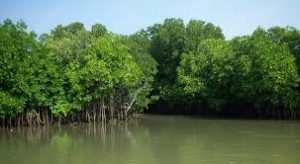
Sundarbans is a vast mangrove forest in the coastal region of the Bay of Bengal, located in the delta region of Padma, Meghnaand Brahmaputra river basins.
- Bangladesh part of Sundarbans is in Khulna Division and its Indian part is in West Bengal State.
- In 1997, Sundarban was recognized as UNESCO World Heritage Site.
- Sundarbans forest is home to Royal Bengal Tiger.


