


On December 30, 2019, the Union Minister for Environment, Forest and Climate Change(MoEFCC), Shri Prakash Javadekar released the biennial “India State of Forest Report (ISFR)”, in New Delhi. The report assesses forest and tree resources in India biennially and is published by the Forest Survey of India (FSI). The ISFR-2019 is the 16th report in the series since 1987.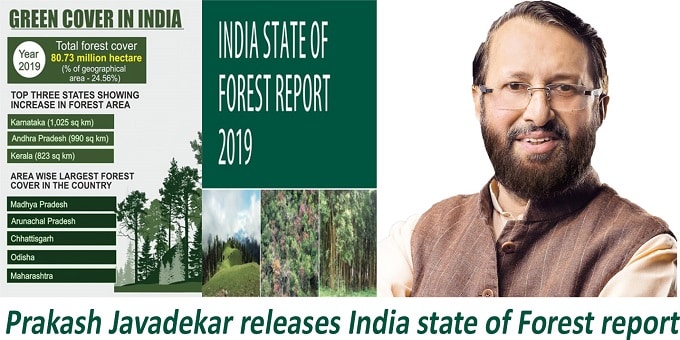

As per the recent assessment made, the total forest and tree cover of the country now stands at 80.73 million hectares which is 24.56% of the geographical area of the country.
When compared to the 2017assessment, the total forest and tree cover in the country made an increase of 5,188 sq. kilometers.
- Forest cover: 3,976 sq km increase in the forest cover has been observed. Range increase in forest cover is first observed in open forest followed by very dense forest and then in moderately dense forest.
- Tree cover: 1,212 sq. km increase in tree cover has been observed.
i.Top states with increased forest cover: Karnataka topped among the states with an increase in forest cover with area of coverage of 1,025 sq. km. it was followed by Andhra Pradesh (990 sq km) and Kerala (823 sq km) in the 2nd and 3rd place respectively.
ii.Area wise toppers: In terms of largest forest cover in the country by area wise, Madhya Pradesh (MP) has the largest forest cover. It was followed by Arunachal Pradesh, Chhattisgarh, Odisha and Maharashtra in the 2nd, 3rd, 4th and 5th place respectively.
iii.Forest cover as a percentage of total geographical area: Mizoram (85.41%), Arunachal Pradesh (79.63%), Meghalaya (76.33%), Manipur (75.46%) and Nagaland (75.31%) ranked 1st, 2nd, 3rd, 4th and 5th place respectively in terms of forest cover as a percentage of total geographical area.
iv.Top rankers in mangrove coverage: Mangrove cover in the country has been separately reported in the ISFR 2019 and the total mangrove cover is 4,975 sq km which has increased by 54 sq Km compared to the previous assessment of 2017. Top three states showing mangrove cover increase are Gujarat (37 sq km) followed by Maharashtra (16 sq km) and Odisha (8 sq km) in the 1st, 2d and 3rd rank respectively.
v.Bamboo bearing area: The extent of bamboo bearing area of the country has been estimated to be 16.00 million hectares which has increased by 0.32 million hectare from the previous assessment.
vi.Carbon stock: The total carbon stock in the forest is estimated to be 7,124.6 million tonnes with an increase of 42.6 million tonnes from previous assessment made. The annual increase in the carbon stock is 21.3 million tonnes, which is 78.2 million tonnes CO2 (carbon dioxide) equivalent.
- Soil Organic Carbon (SOC) represents the largest pool of carbon stock in forests, with an estimated amount of 4,004 million tonnes. It contributes 56% to the total forest carbon stock of the country.
vii.Wetlands coverage: There are 62,466 wetlands covering 3.8% of the area.
viii.Forest coverage accuracy:The accuracy of forest cover classification were 93.17%. The accuracy of classification between forest and non-forest classes were 97.20%.
ix.Fire prone area coverage: The present report fire prone forest areas of different severity classes were mapped in the grids of 5km x 5km based on the frequency of forest fires in the last 14 years.
x.Report coverage: The report covers information mainly on forest cover, tree cover, mangrove cover, growing stock inside and outside the forest areas, carbon stock in India’s forests, Forest Types and Biodiversity, Forest Fire monitoring etc.
xi.Satellite data: The satellite data was based on interpretation of LISS-III (Linear Imaging Self Scanning Sensor-III) data from Indian Remote Sensing satellite data (Resourcesat-II) with a spatial resolution of 23.5 meters. The scale of interpretation was 1:50,000 to monitor forest cover and forest cover changes at District, State and National level.
- Satellite data for the entire country was taken from NRSC (National Remote Sensing Centre) for the period October, 2017 – February, 2018.
- It is also to be noted that for the 1st time Ortho-rectified satellite data has been used for forest cover mapping.
xii.FSI mapping details:
- FSI has carried out mapping of forest types of India as per the Champion & Seth Classification (1968), for the first time in the year 2011 based on the baseline forest cover data of 2005.
- Refinement in data and updating the forest type maps as per the latest baseline forest cover was initiated in the year 2016 and has been completed in 2019. Click here to know more.
Rank:
| Rank | Increase in forest area | Areawise largest forest cover | Increase in mangrove cover |
| 1 | Karnataka | Madhya Pradesh | Gujarat |
| 2 | Andhra Pradesh | Arunachal Pradesh | Maharashtra |
| 3 | Kerala | Chattisgarh | Odisha |
About Ministry of Environment, Forest and Climate Change (MoEFCC):
Founded- 1985.
Headquarters- New Delhi.
Minister of State(MoS)- Babul Supriyo.


